
The Oceanic Bridge Replacement Project
The Oceanic Bridge Replacement Project website can be found HERE.
Introduction from the Project website: The Oceanic Bridge provides an important link between the Borough of Rumson and the Township of Middletown for vehicles, bicyclists, pedestrians, and emergency response vehicles. Additionally, it provides an emergency evacuation route for Shore communities.
In recent years the bridge has required numerous repairs which have impacted the daily activities of local residents and businesses. A long-term solution is necessary to avoid future disruptions and maintain the connection between the Borough of Rumson and the Township of Middletown, as well as maritime activity on the Navesink River.
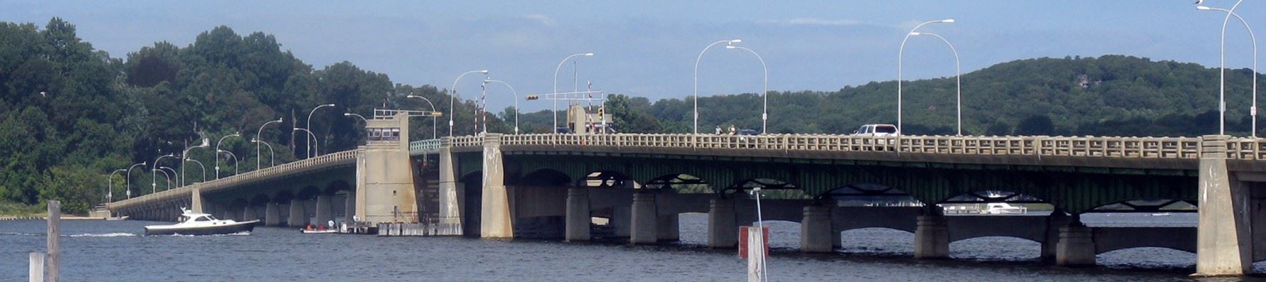
Constructed in 1939, the Oceanic Bridge is in need of a major rehabilitation or replacement. The County is conducting this study in conjunction with the North Jersey Transportation Planning Authority (NJTPA) and the New Jersey Department of Transportation (NJDOT). The Local Concept Development (LCD) Study phase is now complete. The next phase of design is Local Preliminary Engineering, which is tentatively scheduled to begin in 2022.
The US Coast Guard released a Preliminary Public Notice 1-187 on July 21st 2021 that requested comments regarding its determination of a new bridge clearance (height above mean high water) to be 65 feet if the design is a fixed bridge (that is not an opening bridge like the present bridge.
Navesink Maritime Heritage Association's position is described below:
Navesink Maritime Heritage Association is a member organization with members who undoubtedly may have different opinions on the Oceanic Bridge replacement. NMHA does not take a side with regard to a preferred bridge replacement option, but as an organization that has been involved in Navesink River activities since 1999, it can possibly provide insights that may not come to the fore when stakeholders with a narrow focus are making their point.
In this regard NMHA provides the below discussion that suggests that the optimal solution is the construction of an opening bridge with a modestly increased air draft. The focus should be on finding the most cost-effective long-term solution within that design goal to prevent the Upper Navesink from becoming a maritime backwater.
The Navesink River and the communities upstream from Oceanic Bridge have been navigable waters since the first humans arrived. Red Bank, Middletown, Fair Haven, and Rumson all had direct access to the rest of the world as long as vessels calling at the river did not exceed a draft of 6 or 7 feet.
For a significant period, sailing vessels were the main connection between the river and the rest of the world, and these sailing vessels had masts in excess of 65 feet. This was a specific low draft wide beam type of sailing vessel called a Shrewsbury Packet. These commercial sailing vessels no longer call on the upper Navesink, but still are a component of our heritage. For the 250th anniversary of our country’s independence NMHA is in the early stages of chartering the closest sailing copy of a Shrewsbury Packet, the schooner Pioneer. This vessel has an air draft of slightly less than 65 feet with topmasts struck and a hull draft of six feet. As such, with the present bridges, the vessel can sail to Red Bank.
There is a special significance to a vertical clearance of 65 feet. Over a very long period of time, the USCG has set the height of fixed spans at 65 feet in their main navigable waters. This is a standard that then resulted in a chicken and egg situation where sailing vessel designers limit mast height to a little less than 65 feet to allow their vessel to range over all the navigable waters in the United States.
This philosophy was applied to the Highlands Bridge and also to the Rumson/Sea Bright Bridge (which will be an opening bridge due to limitation in bridge approach slopes) and was applied to the Oceanic Bridge in its original basic replacement design.
Almost immediately it became apparent that such a bridge would be much more visually intrusive than the present elegant structure, and a spirited debate has ensued.
From a design point of view, the options range from an in-kind replacement to a fixed 65-foot span and every option in between. To provide improvements in traffic flow there is a general consensus that a somewhat higher span would be nice, and undoubtedly a very elegant bridge can be constructed that has a closed clearance of, say, 35 feet. That would be a benefit to many boaters, bridge users, and those who cherish the beauty of the river alike.
However, once the discussion moves to the ability of vessels with air drafts greater than, say 35 feet, to reach Red Bank, Rumson, Fair Haven, and Middletown, the debate takes on greater passion. This is caused by a Federal Rule that removes federal funding from bridges that are built with opening spans, and, as such, if an opening bridge with an air draft of less than 65 feet is chosen, by federal rule, the state and county lose a significant portion of the funding for the construction of the bridge.
Some people may wonder why a reduction in air draft is an issue since only on rare occasions do vessels with tall masts up to 65 feet sail upstream from the Oceanic Bridge. Should the community pay more for an opening bridge to allow access to a few vessel owners with tall masts?
It may be more beneficial to regard this issue from a different point of view. There actually is a community point of view as far as isolating Red Bank, Rumson, Fair Haven, and Middletown from the common air draft standard is concerned. Instead of being part of the United States navigable communities, with a lower fixed bridge, the upper Navesink will now become a much-diminished maritime player. At this time, it may not have a serious impact, but we should never forget that a low bridge is forever.
At the 250th anniversary of our country, we may still be able to celebrate our heritage in true historical fashion by bringing a vessel like the Pioneer to the upper Navesink, but that will be the last time, forever. That would only be a rare event, but it needs to be remembered that nothing stays the same, and with a drive to sustainable energy, sail-powered vessels are again coming to the forefront and may yet again become a factor for the upper Navesink. It is certainly interesting to note that more and more cruising sailing catamarans are being built. These catamarans draw much less water than monohull sailboats and large cruising cats with masts up to 65 feet in height would not have any water depth issues on the Navesink. Such cruisers would find the Navesink and its shores a delightful destination. Furthermore, a reduction in bridge clearance would also remove an important hurricane shelter in our area for vessels with taller masts.
Disregarding the funding picture, we all agree on the same solution: A somewhat higher bridge to reduce bridge openings, but with the ability to open when boats with air drafts up to 65 feet visit the Upper Navesink. This does not have to be an on-demand bridge. At this stage, periodic or pre-scheduled openings would certainly provide a balanced approach that can satisfy everyone around the river and does not delegate the upper Navesink to a maritime backwater forever.
Based on the above, NMHA’s suggests a balanced solution to the Oceanic Bridge. As a community let’s agree on replacing the Oceanic Bridge with an opening bridge with a modestly increased air draft and focus on finding the most cost-effective long-term solution within that design goal. To finance this solution will take more energy and financial input by lawmakers, regulators, and possibly even riverfront private stakeholders, but it will result in the best solution. Our community and the Navesink deserve no less than the best solution. Our upstream Navesink communities, our county, and our state contribute very strongly to the greater economy and today we are making a rare request to the federal rule-makers to do the right thing for us.